The A.Ortelius/ P.Querini Atlas.
 
1528-98
 
 
Abraham Ortel, better known as Ortelius, was born in Antwerp and after studying Greek, Latin and mathematics set up business there with his sister, as a book dealer and 'painter of maps'. Travelling widely, especially to the great book fairs, his business prospered and he established contacts with the literati in many lands. On one such visit to England, possibly seeking temporary refuge from religious persecution, he met William Camden whom he is said to have encouraged in the production of the Britannia.
A turning-point in his career was reached in 1564 with the publication of a World Map in eight sheets of which only one copy is known: other individual maps followed and then - at the suggestion of a friend - he gathered together a collection of maps from contacts among European cartographers and had them engraved in uniform size and issued in 1570 as the Theatrum Orbis Terrarum (Atlas of the Whole World). Although Lafreri and others in Italy had published collections of 'modern' maps in book form in earlier years, the Theatrum was the first uniformly sized, systematic collection of maps and hence can be called the first atlas, although that term itself was not used until twenty years later by Mercator.
The Theatrum, with most of its maps elegantly engraved by Frans Hogenberg, was an instant success and appeared in numerous editions in different languages including addenda issued from time to time incorporating the latest contemporary knowledge and discoveries. The final edition appeared in 1612. Unlike many of his contemporaries Ortelius noted his sources of information and in the first edition acknowledgement was made to eighty-seven different cartographers.
Apart from the modern maps in his major atlas, Ortelius himself compiled a series of historical maps known as the Parergon Theatri which appeared from 1579 onwards, sometimes as a separate publication and sometimes incorporated in the Theatrum.
The Epitome printed in Italy is an imitation of the original edition with the plates cut in Italy. Its popularity among Italian readers is clearly demonstrated by the fact that editions were printed as late as 1724. This is the fourth (from 9) edition, and is printed in Venice. Works of considerable charm, the small-format editions of Ortelius' great work made the work of the master available to a wider readership. 

Front Page of Atlas. Price $ 95.00

Mapmaker: ORTELIUS,A
Publisher: QUERINI,P.
Title: Theatro del Mondo di Abraamo Ortelio..
Place/Date: Venice 1667
Size: 140x950 mm
Colouring:
Uncoloured as published.


The general condition of the 108 maps in the Atlas is fine to very fine with only a few maps having a mild, minor water stain towards the upper left part of the map page/image which does not seriously detract. Two regional maps of Germany are with mild to severe off setting and are priced accordingly. Two other maps had  small tears which were expertly repaired; these are also suitably priced.  Should you require a more detailed account of a map that interests you please email me. elmonica@cytanet.com.cy 
The size of a map page is 13.5x9.5 cms. with the actual map image measuring 10x7.5 cms. Margins are wide for maps of this size, with a narrower margin always at the bottom. 
Prices are in U.S. $ 
 
 
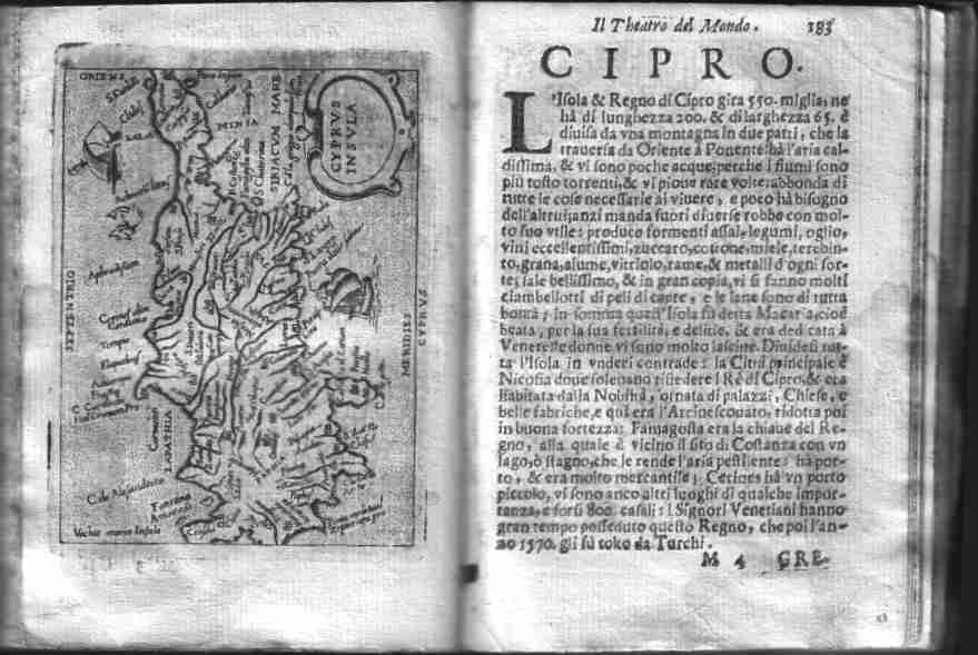
The World


Africa


America


Asia


Europe


Tartaria ( inc. California
and Japan)
Central Africa
 
North Africa
 
Egypt
 
Tunisia
China
 
Holy Land
 
India (South East Asia)
 
Persia
 
Turkey
 
Ottoman Empire
 
 
Austria (2 pages)
Balkan States (2 pages )
Baltic States
Belgium & Holland (10 p.)
Corfu
Crete
Cyprus
Czechoslovakia
Denmark
England
France (18 pages)
Germany (9 pages)
Greece 
Hungary
Ireland
Ischia
Italy (20 pages)
Luxembourg
Malta
Poland (3 pages)
Portugal
Prussia
Russia
Sardinia
Scandinavia
Scotland
Sicily
Spain (4 pages)
Switzerland
Terceira
Tyrol
Zator