Price: CyP 950.00
Maps. Cyprus. Page 140.
|
|
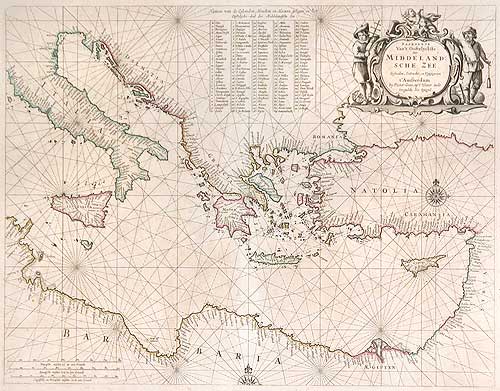
| Paskaerte Van’t Oostelyckste Der
Middelandsche Zee... by GOOS, PIETER.
Amsterdam 1666. 51 x 40 cms. Published in De Zee Atlas ofte Water-Weereld
in 1666, this is an excellent general chart of the eastern
Mediterranean, centered on Greece. The chart is beautifully engraved
with a large decorative title cartouche in the upper right. The coasts
are crowded with placenames, and an extensive key locates 111 of the
smaller islands. “Pieter Goos was one of Amsterdam’s most prominent
publishers of nautical charts. The reputation of his firm was matched
only by that of the publishing houses of Blaeu and van Keulen” --
Putnam. His maritime atlas of the world is one of the most complete sea
atlases published prior to the appearance of Van Keulen’s Zee-Fakkel in
the 1680’s. Famed for its beauty, Koeman notes that “Goos’s sea-atlas
was more intended for the book-lover than for the seaman.” Pieter Goos
(ca. 1616-1675) was the son of famed engraver and cartographer Abraham
Goos (ca. 1590-1643) who engraved maps for Kaerius, Hondius, Jansson,
Visscher, and Speed. Original outline colour. Some very minor foxing,
otherwise an excellent example. Ref: Tooley, Dictionary of Mapmakers, p.
253. Price: CyP 950.00 |
Page 131 132 133 134 135 136 137 138 139 140 141 142 143 144 145 146 147 148 149 150 151 152 153 154 155 156 157 158 159 160