Price: CyP 1,300.00
Maps. Cyprus. Page 87
|
|
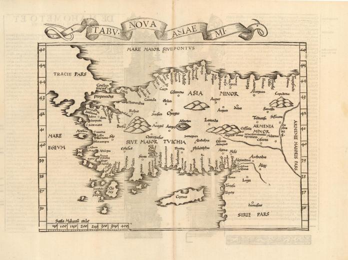
| Tabu Nova Asiae MI
by Fries/Servetus.
From: Claudii
Ptolemaei Alexadrini Geographicae Enarrationis Libri Octo. Ex Bilibaldi.
Lyon 1535.
Woodcut.38.5x30.5 cms. Wide margins. Slight see through of text of verso
on to recto as seen in my scan. One of the earliest maps showing Cyprus.
This map
with the Karpas Peninsula pointing
westwards. From the 1541 edition of Ptolemy, Karpas was pointing
eastwards.
Title above the map is in a fancy
banner-style cartouche. On verso is Latin text, some very fine
architectural woodcut illustrations attributed to Hans Holbein of Basel,
and the title "de Mahometo et Turcarum Origine et moribus." Published in
Lyon by Melchior and Gaspar Treschsel. This map is from the atlas often
referred to as 'editio prima Serveti' after its editor, Michael
Villanovus, better known as Servetus, who was burned alive in 1553 for
heresy. The map of the Holy Land from this atlas had on its verso a
comment suggesting that the area was not as beautiful and fertile as
generally believed, but was actually barren, according to travelers.
This statement was one of the pieces of evidence used against Servetus.
Calvin had many copies of the 1535 atlas confiscated and burned with
Servetus. Price: CyP 1,300.00 |