Price: CyP 1500.00
Maps. Cyprus. Page 90
|
|
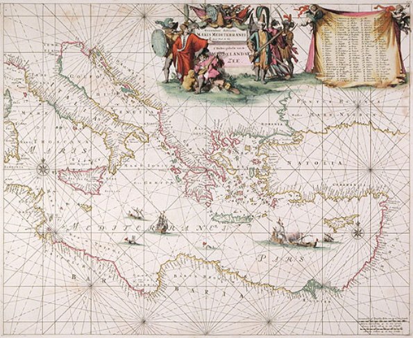
| Orentalior distritus Maris Mediterranei...
by DE WIT, FREDERICK.
Amsterdam. 1675. 59x48 cms. Original colour. Small clean split in top
centerfold (repaired), otherwise excellent condition.This is a beautiful
and impressive sea chart of the eastern Mediterranean stretching from
the islands of Corsica and Sardinia in the west to Syria , Turkey and
Cyprus in the east, and includes part of the southern shore of the Black
Sea. Frederick De Wit’s skills in cartography earned him the reputation
as “one of the most famous engravers of the second half of the
seventeenth century” -- Koeman. After serving as apprentice in the Blaeu
firm, De Wit carried the torch as Amsterdam’s leading map publisher
after the Blaeu firm was destroyed by fire in 1672. Most atlases issued
by De Wit consisted of land maps, but in 1675 he published the
magnificent Tabulae Maritimae. This work consisted of twenty-seven sea
charts of waters throughout the world. The charts are notable for the
embellished and finely etched cartouches. “The cartouches of the maps of
the second half of the seventeenth century are often etched, a technique
giving a looser impression” -- Putnam. Also view Louis Renard's map
which is based on De Wit's work and was published in 1715.
Click Page 69. Price: CyP 1500.00 |