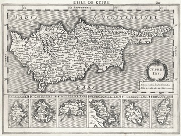
| CYPRUS INS. ( L' Isle de Cypre ),
by J. Hondius/ Van Waesberge. Amsterdam. Latin
Edition. 1632 [1676]. 26 x 19 cms.
Inset of Stalimni, Chius, Mitilene, Negroponte,
Cerigo and Rhodus. It comes from Van Waesberge's
"Nieuwe
en beknopte Uytbeeldinge". A little
known map of Cyprus, much larger than the normal size of c19 x 14 cms.
of the earlier period. Unknown to Stylianou, Zacharakis, BoC and
S.Ioannou. Your chance to own something unknown! Wide borders and in
excellent condition.
[Van
Waesberge was the son-in-law of Jan Jansson, succeeding to the
publication of cartographic material, much of which had originated with
Mercator and Hondius. This atlas originated with Cloppenberg's
"middle-size" format in his Mercator-Hondius atlases from 1630 through
1636. These plates were altered somewhat (cartouche & sea area),
enlarged by c 33% and reissued in this atlas; Kaerius being the probable
engraver.]
Price: CyP 625.00 |